


Rover Kit with iHand20
iHand20 Controller with Tersus-Survey Software
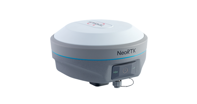 The NeoRTK is a new generation GNSS RTK system. With an internal high-performance multi-constellation and multi-frequency GNSS board, the NeoRTK can provide high accuracy and stable signal detection. The high-performance antenna can speed up the time to first fix (TTFF) and improve anti-jamming performance. The built-in large capacity battery can support up to 10 hours of field work. The radio module in the package supports long communication ranges. The rugged housing protects the equipment from harsh environments.
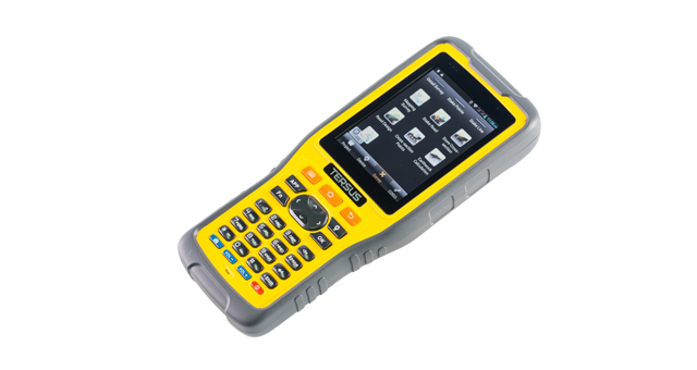
About the iHand20 ControllerThe iHand20 is a professional GNSS controller equipped with an alphanumerical keypad, a 3.7” sunlight readable screen and a powerful processor, which is designed to improve surveyors’ productivity.
With a rugged IP68-rated enclosure that can survive 1.2 meter free drops, the iHand20 is a perfect solution for the harshest operating environments. In addition, the Li-ion, 6500mAh-capacity battery can support prolonged fieldwork.
With a rugged IP68-rated enclosure that can survive 1.2 meter free drops, the iHand20 is a perfect solution for the harshest operating environments. In addition, the Li-ion, 6500mAh-capacity battery can support prolonged fieldwork.
Features
Supports multiple constellations & frequencies
- GPS: L1C/A, L1C, L2C, L2E, L5
- GLONASS: L1C/A, L1P, L2C/A, L2P
- BeiDou: B1/B2
- GALILEO: GIOVE-A, GIOVE-B, E1, E5A, E5B
- SBAS: L1C/A, L5
- GPS: L1C/A, L1C, L2C, L2E, L5
- GLONASS: L1C/A, L1P, L2C/A, L2P
- BeiDou: B1/B2
- GALILEO: GIOVE-A, GIOVE-B, E1, E5A, E5B
- SBAS: L1C/A, L5
Positioning update rates: 1Hz, 2Hz and 5Hz
Supports 16GB internal storage and up to 32GB external Micro-SD card
Supports tilt compensation and electronic bubble
Rapid RTK integer ambiguity resolution
Controller and software make host system operation more convenient
Specifications
GNSS
-
GPS
L1C/A, L1C, L2C, L2E, L5
GLONASS
L1C/A, L1P, L2C/A, L2P
BeiDou
B1/B2
Galileo
GIOVE-A, GIOVE-B, E1, E5A, E5B
SBAS
L1C/A, L5
System & Data
-
Operating System
Linux
System Initialization
3s
Storage
16GB internal storage, up to 32GB external Micro-SD card
RTK Format
CMR, CMR+, sCMRx, RTCM2.X/3.X
Positioning
-
High-Precision Static (RMS)
- Horizontal
3mm + 0.1ppm
- Vertical
3.5mm + 0.4ppm
Static and Fast Static (RMS)
- Horizontal
3mm + 0.5ppm
- Vertical
5mm + 0.5ppm
RTK (RMS)
- Horizontal
8mm + 1ppm
- Vertical
15mm + 1ppm
PPK (RMS)
- Horizontal
8mm + 1ppm
- Vertical
15mm + 1ppm
Network RTK (RMS)
- Horizontal
8mm + 0.5ppm
- Vertical
15mm + 0.5ppm
SBAS Positioning Accuracy
0.5m
Initialization (Typical)
<10s
Initialization Reliability
>99.9%
Tilt Measurement
≤3cm
Electrical
-
Battery
5000mAh x2
Battery life
Up to 10 hours working per battery (in RTK rover mode)
Input Voltage
6V~28V DC
Power Consumption (typical)
4.2W
Communication
-
3G
TD-SCDMA, WCDMA, EDGE, GPRS, GSM
WiFi
802.11b/g
Bluetooth
2.0 x1
USB
USB 2.0 x1
Serial Port
RS232 x1
Interal Radio
- Power
2W
- Frequency
403MHz~473MHz
- Distance (Typical)
5km
External Radio Station (Optional)
-Power
5W/35W
- Frequency
410MHz~470MHz
- Distance (Typical)
15km
Physical
-
Size
Φ 153 x 83mm
Weight
1.2kg including battery
Dust- & Waterproof
IP67
Pole drop onto concrete
2m
Operating Temperature
-45℃ ~ +75℃
Storage Temperature
-55℃ ~ +85℃
Relative Humidity
100% not condensed
Kami adalah perusahaan yang bergerak dalam bidang Penjualan, Sewa, Service & Kalibrasi Alat-alat Survey dan Pemetaan.
Kami melayani wilayah/ kota besar di Indonesia : Jakarta, Tangerang, Bogor, Bekasi, Depok, Karawang, Purwakarta, Bandung, Palembang, Lampung, Bengkulu, Jambi, Padang, Pekanbaru, Bangka Belitung, Riau, Pangkal Pinang, Medan, Batam, Samarinda, Balikpapan, Banjarmasin, Makassar, Maluku, Manado, Gorontalo, Surabaya, Bali, Banten, Jawa Barat, Jawa Tengah, JawaTimur, Sumatera, Kalimantan, Sulawesi, dan Papua
Informasi Lengkap Harga & Pembelian Hubungi
Nata Sukmaja
Tlp&WA : 081282535818
email : 4stars.equipments@gmail.com
Labels:
GPS Geodetik,
GPS Geodetik / GNSS TERSUS Neo RTK
Thanks for reading GPS Geodetik / GNSS TERSUS Neo RTK. Please share...!
